|
The Databases - VHF DATABASE
The VHF database for WW Grid Locators.
The VHF database allows tracking of worked and confirmed status of logged QSOs and other related functions
throughout the software.
The VHF database QSO list will be updated automatically when a new grid locator is worked or
confirmed in the Log with each NEW band/mode during the logging input.
The database is only updated for VHF QSO unless the 'Include HF' option is enabled
menu/Database/VHF Locator/Include HF is enabled.
Only ONE QSO from the Log is added to the VHF database for each new grid/band/mode,
thus not every QSO is added to the VHF database.
To enable the update function to operate, the grid locator MUST be the first entry in the Log 'Remarks' field.
The normal "IO82WM" format is expected, but grid can be added in its shortened form "IO82",
grid locators do not require a syntax prefix, but must be the first item entered into the Log Remarks field.
The old QRA system is not supported.
The VHF database can be viewed and queried directly:
menu/Databases/VHF/View
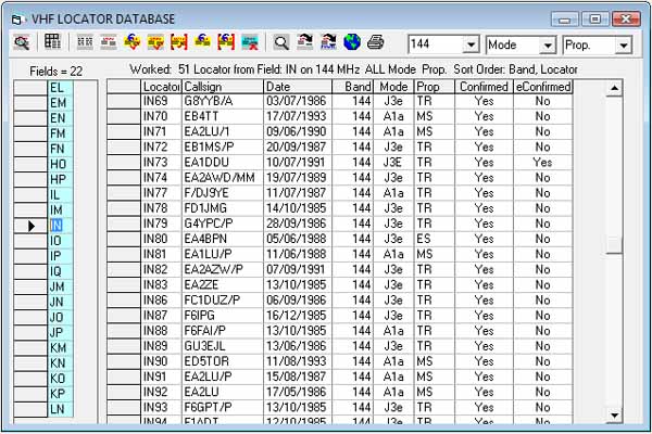
The VHF database window.
If you have no interest in VHF or grid locators and don't require grid status reports,
the function can be disabled with menu/Database/VHF/Auto Check.
The ‘white’ list displays grid Locator reference and details of QSO entered in the VHF database,
only one entry per band/mode.
Both Grid field list and QSO list displays are modified by the last selected filter,
e.g. worked, confirmed, etc., using the appropriate toolbar buttons.
Grid and QSO lists interact accordingly.
Switch between a visual representation of the grid field and the QSO list using toolbar option #2
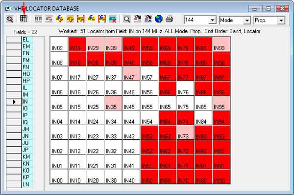
Only one grid field can be displayed at a time.
The left ‘blue’ columns lists grid locator fields, this list will be modified
to reflect any filtering by the toolbar query buttons.
Changing the field selector will display corresponding grid field.
A summary of the query and results are displayed at the top of each list.
The summary will inform of total grids worked/confirmed depending on what filters are set.
The Toolbar Query Icons.
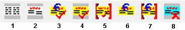
| 1 | All | All grids and all QSO entered in the VHF database. |
| 2 | Worked | All grids worked and related QSO in the VHF database. |
| 3 | Any Confirmed | All grids confirmed and related QSO in the VHF database. |
| 4 | QSL Confirmed | All grids confirmed by QSL and related QSO in the VHF database. |
| 5 | QSL Confirmed Exclusive | All grids confirmed only by QSL and related QSO in the VHF database. |
| 6 | eConfirmed** | All grids confirmed by LoTW** and related QSO in the VHF database. |
| 7 | eConfirmed Exclusive** | All grids confirmed only by LoTW** and related QSO in the VHF database. |
| 8 | Worked/Not Confirmed | All grids worked but not confirmed and QSO awaiting confirmation. |
N.B. There is no 'Wanted' query option. **N.B. VHF grid locator awards may not accept LoTW or other electronic confirmations.
Further filters can be applied using the toolbar drop-own band, mode and prop (propagation) filters.
The band, mode and prop filter lists mirror the contents of the Log drop-down lists (band/mode/prop)
If a required band, mode or prop is not present in the VHF filter list, it must be added to the Log band/mode/prop list.
menu/Options/Settings/Custom lists
'Digi' modes (e.g PSK, RTTY etc) can be queried individually or grouped as "All Digi",
a trailing space character follows the digi-mode being added to the VHF database to facilitate this grouping, e.g."PSK "
The trailing space must be observed when entering or editing data modes manually in the VHF QSO list.
Toolbar option #1 will find the selected QSO corresponding in the Log.
Toolbar option #11 - Search; query the VHF grid locator for specific criteria.
Toolbar option #12 will export the QSO list as a text delimited file.
Toolbar option #13 will allow the export of your most wanted squares in MWD file format specific for the "Most Wanted" (grid squares)
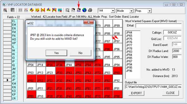
A grid can be added to the list by clicking on the wanted grid in the Field 'view'
A warning message appears if the grid selected fall outside the radius distance set in the options.
Select each field of interest and add grids to the list, care must be taken so that 'impossible' grids are not selected
e.g. those without any land mass.
The MWD file is in ASCII text and can be viewed in Windows Notepad if required.
The file is saved in location ..\Winlog32\Output\*bandselected_*mycallsign*.mwd
Toolbar option #14 will print the QSO list.
Fields not required in the print-out can be ignored by narrowing the field width by dragging the column separators to zero (hidden).
The VHF database can also be updated with the Log Check Robot (LCR)
It will be necessary to use the Log Check Robot after importing from another Log program.
Speed logging or contest operation do not update the VHF database so it will be necessary to run the Log Check Robot
through any new QSOs added during these periods.
A separate help section deals with the Log Check Robot.
The software also queries the VHF database for status of DXCluster spots; right mouse-click menu look-up Grids and other functions.
Special Functions
Maps
This feature is available only to registered users who have the Google Maps interface (API) functioning.
A brilliant add-on to the VHF database which enables display of grids worked in the Google Maps API, including satellite view.
Single grids, complete fields or a complete worked 'world' can be displayed.
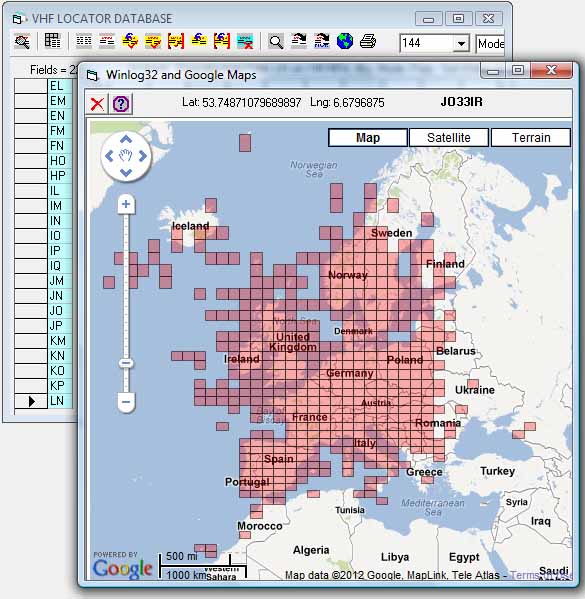
To display a grid field on the map, click the required grid field in the VHF database grid (blue) field list,
and click on the VHF Database toolbar 'map' icon
(this icon only appears when google maps has been enabled), the whole field will be drawn,
this can be repeated for other fields to display a cumulative map.
The example shows G0CUZ 144MHz worked map.
The map overlay colour can be changed in the Google maps options
menu/Options/Google Maps/Options-Fill Colour, the opacity of the fill colour can also be set for best effect.
To draw a single grid on the map, click on a grid in the QSO list.
To overlay confirmed grids, add worked grids first, then re-query 'Confimed' (toolbar option) and add these to the existing, the grid 'colour' will intensify.
See the separate help section for details and requirements of the Google maps API interface.
The old European QRA system.
Since the 1980's the Maidenhead grid locator has been universally adopted for VHF positional information, before this time the old European QRA system was widely used.
Winlog32 can convert QRA that may exist in old paper logs to the current grid locator system using an in-built function in the Log 'Remarks' field.
Enter a "~" (tilde) character before a QRA in Remarks will automatically generate the relative grid after the first two letters of the QRA are entered followed by the original QRA.
Thus entering "~YM" will generate "IO82 ~YM"
This function has limitations due to the ambiguities this system had but most Western European QRA will convert correctly.
VHF GRID LOCATOR SUMMARY
New 2017
This option will show a summary of multiple VHF Bands and modes.
The summary relies on data from the VHF Database (does not work with log data)
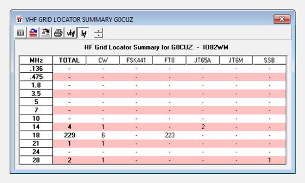
Two different views are possible one showing Grid Locators worked (above) and the other showing the worked and confirmed status for each band.
HF grid locators can also be queried with using appropriate toolbar options.
VHF & HF results can be displayed together when both toolbar options are selected.
The grid row height can be manipulated to some extent using the toolbar up/down arrows, where a more compressed or enlarged table view is required.
Toolbar Options allow exporting the raw data, or an image representing the summary for use in
web browsers etc., the image is exported in an uncompressed bitmap (.BMP) format.
If a compressed image is required - this must be done in external image processing software.
The bitmap only represents the actual viewable area, so if the grid exceeds the viewable area, the grid can be resized as required.
The Bands listed are taken from those in the Custom Lists as set in
Options/Settings/Custom Lists
The Modes represented are also taken from the Custom Lists.
HF totals may only be visible if menu/Database/VHF Locator - Include HF
option has been enabled to add HF QSO to the database.
If the totals do not tally, it is likely that modes are present in the VHF database that are
NOT in the Custom Mode List and should be corrected, either by adding corresponding Mode(s) to the Custom List
or manually editing those modes in the VHF database.
Maintenance.
Removing a QSO from the VHF database.
Click cursor on the QSO callsign in the 'worked' list to select it.
Click cursor on the adjacent left grey |>| pointer column which will select the complete line.
Press the keyboard DELETE key to complete the deletion.
N.B. This does NOT delete the associated QSO from the Log database.
|